
Spending time in the archives is a staple for all historians. Finding, analyzing and reporting on primary sources are the necessary steps for preparing well researched history books and articles. However, physically visiting historical sites germane to research projects are just as vitally critical. Personally experiencing the geographic advantages and obstacles of a particular area is necessary to properly envision and interpret an historical event.
A great example is the New Year’s Eve 1775 Battle of Quebec in which the American Rebel army under the direction of Maj. Gen. Richard Montgomery assaulted the British garrison in Quebec during a blinding snow storm. To capture the town and its garrison required the Rebels to storm a highly defensible walled city located on a bluff overlooking the St. Lawrence River. At the apex, sat the imposing Cap-aux–Diamants Reboubt, marked by the flag in the picture below.

The Redoubt is over 200 feet above the St. Lawrence River protected by steep cliffs and overgrown vegetation.
The landward approach is equally daunting due to the high stout stone walls surrounding the city. While certainly not as imposing as the 19th and 20th century additions depicted below, the 18th century Quebec’s walls were formidable, especially as the Rebels lacked heavy artillery to batter them into submission.

As a result Montgomery decided on a long shot battle plan designed to confuse a cold, distracted British garrison. Montgomery divided his forces into four units. From the west, two units would each engage in feigning attacks. The militia unit under the command of Jacob Brown would engage the British forces at St. Johns Gate (pictured above) and a unit under the command James Livingston would distract the Cap-aux-Diamonts fortifications (see below) from outside the city walls. Montgomery hoped that the British would believe that these feints were the main Rebel attack would move reinforcements from the lower town to the western walls. Taking advantage of a distracted enemy, Montgomery and Benedict Arnold would lead two separate units, one from the west along the St. Charles River and the other from the east along the St. Lawrence River to assault the lower town. Once the lower town was taken, the combined Rebel forces would travel up city streets into the upper town and capture the ultimate fortifications at Cap-aux-Diamonts (pictured below).

To further tilt the Rebel odds, they attacked during a blinding snow storm to foster an undetected approach into the city’s fortifications.
However, like all battle plans, they go awry at the battle’s outset. Alert British sentries detected the Rebel attack and rang the bells of the Lower Town’s Notre Dame Church which immediately brought the garrison to arms. The narrow streets funneled British cannon grapeshot and musketry fire into the leading Rebel attackers. In looking at Quebec’s streets today (see below), one can image a deadly kill zone, even on a dark, snowy night. A cannon sprewing grapeshot and fifty soldiers and sailors stopped and turned back Montgomery’s much larger column on a street similar to the one in the picture below.

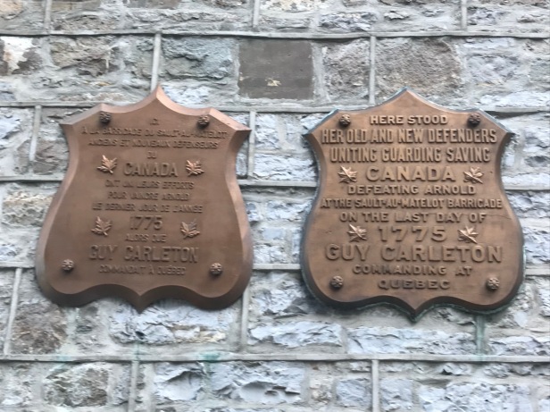
Initially, the column under Col. Benedict Arnold had more success. Advance elements penetrated the the first set of baracades, but became stalled behind the second. Crafty Governor Carleton send a unit to recapture the first barricade thereby trapping the Rebel invaders within the city streets.

Even if Montgomery’s and Arnold’s forces had combined to take the Lower Town, forbidding obstacles remained. The invaders still had to penetrate the upper city stone walls and climb 200 feet up to the top of Cap-aux-Diamonts to take the redoubt. For a view of how daunting a task this was, look at a modern view pictured below.

By viewing the geography today, one can see that Montgomery’s plan while deceptive and audacious, was likely just foolhardy. His chance of capturing Quebec was doomed when he did not transport heavy artillery with his invasion force. Likewise, Arnold’s epic trek through the wilds of Maine, did little to aid the campaign as they also lacked artillery and seige warfare capabilities. The attempt to capture Quebec highlighted a major Continental Army weakness, the lack of artillery, military engineering and seige warfare expertise. Foreign military volunteers and a supporting French Army and Navy would rectify the Continental Army’s lack of professional military capabilities by 1777 at Saratoga and 1781 at Yortown.

The photographs helped me better understand the battle.
LikeLiked by 1 person