
It’s just Vermont!
Yesterday was warm and sunny, perfect for shorts and tee shirts. Today, light snowflakes from long-hanging clouds swirled in a steady wind as I started a solo five-mile circuit hike to Devil’s Gulch via the Long and Babcock trails. 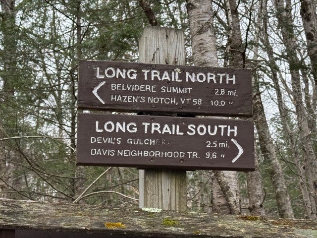 Trailhead marker Of course, before starting, I noticed the Revolutionary War connections with the area. The trailhead lies in the town of Eden, Vermont. In 1781, the renegade Republic of Vermont deeded the town to seventy-two Green Mountain Boys under the command of Colonel Seth Warner. I suspect the soldiers imbued the biblical place name Eden to attract settlers and increase the value of their land grants. While innovative marketing, the soldiers received little benefit, and the area remains lightly developed today. Hazen’s Notch is another Revolutionary War moniker, ten miles in the other direction from my planned trek (see trail sign above). In the 1,793-foot Hazen’s Notch, a stone marker notes that General Moses Hazen partially constructed an eponymously named road to support a Canadian invasion in 1779. The attack did not occur, and the road remained unfinished. My planned route starts on the famous Long Trail at its intersection with Vermont Route 118. The Long Trail runs along the spine of the Green Mountain Range for 272 miles from the Massachusetts line to the Canadian border. Roots, rocks, and gnarly elevation changes slow down even the strongest hikers. Like most Long Trail trailheads, the path starts with an uphill climb. The white-blazed route follows a narrow ridge. After a mile, the trail enters a broad bowl, leaving road noises behind. The quiet allows hikers to look around and enjoy the late fall scenery.It is readily apparent why Vermonters call November stick season. The landscape looks barren, with no leaves on the trees or snow on the ground. Stick season is a great time to hike as the leafless forests provide vistas typically covered by foliage, and there is less mud and no flies. 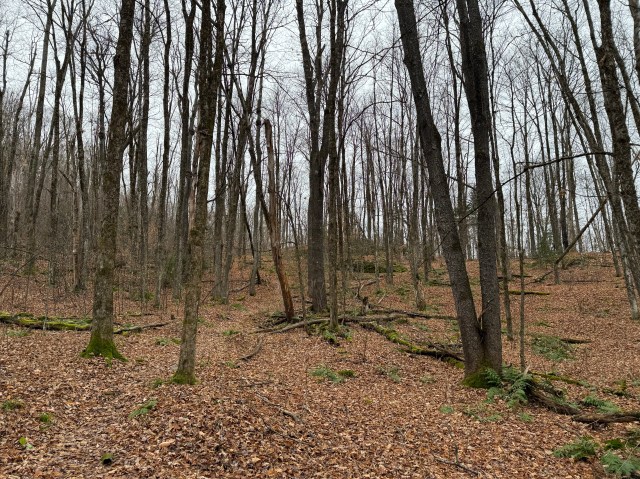 After cresting a ridge, the trail gently descends through a narrow valley with a rocky stream running down the center. Potential animal noises interrupted my calm and quiet hike. Despite peering three hundred and sixty degrees, I could not glimpse the creature and continued in peace. Perhaps my imagination got the better of me as I was alone, or I wished to see one of the five thousand Vermont bears foraging to prepare for winter hibernation. 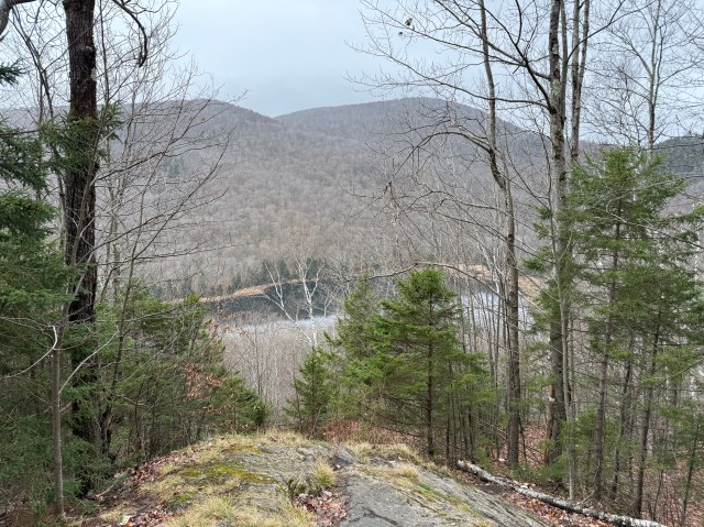 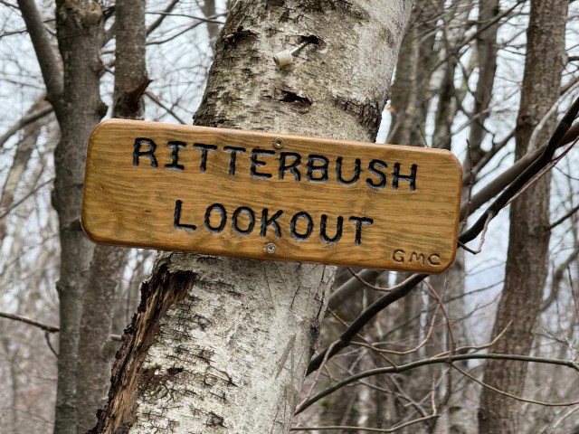 Abruptly, a rocky ledge emerges, presenting a beautiful vista of the placid, undeveloped Ritterbush Lake. From this high perch, trail builders cut the trail straight down the steep hill towards the lake without switchbacks, as is typical of Vermont paths. The trail descends a long stretch of precipitous stone steps remarkably placed many years ago. At the bottom, the trail winds 100 feet above the lake to the southwest, crossing several small streams. 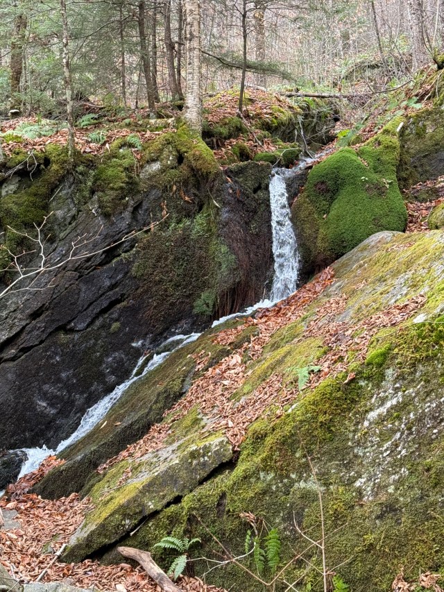 At the lake’s end, the trail intersects with the Babcock Trail, the route back to the start if you wish a circuit hike. It is another 0.7 miles of mostly flat terrain on the Long Trail to the Devil’s Gulch. While the Green Mountain Club installed excellent signage, it is readily apparent when entering the ominously named gulch. 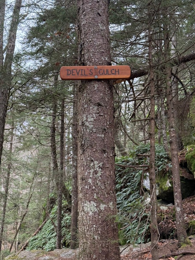 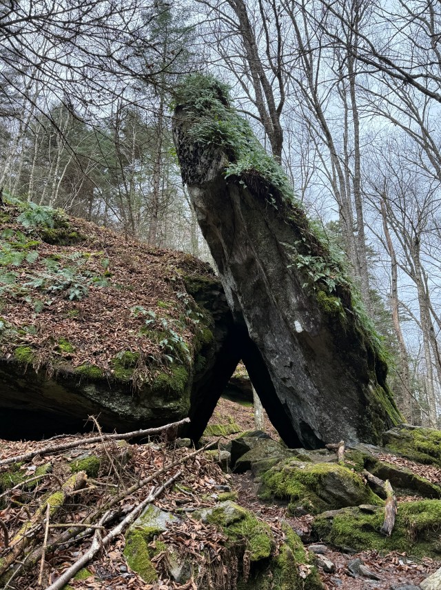 The 0.2-mile Devil’s Gulch is full of large rocks, randomly splayed and punctuated by water drainage. The term gulch is thought to have been derived from the Middle English gulchen, “to gush forth; to drink greedily” (c. 1200). The mid-nineteenth century was the heyday for dubbing geographic features gulches . While quaintly named, the narrow passage is geologically better defined as a defile, a narrow pass between two mountains. It is thought that the term defile originates from the need for an army to narrow its advance to a single column when passing a constricting geographic feature. 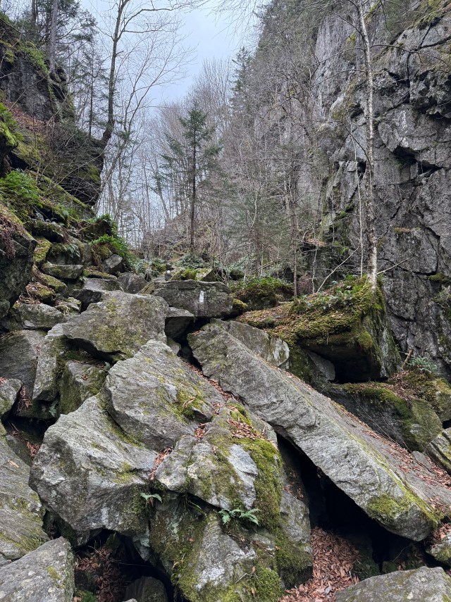 Note the white blaze noting the Long Trail route over the large rocks. After climbing a wooden ladder into the gulch, an exciting rock scramble and slender passages confront hikers. At the gulch’s center, two huge rocks form a narrow “A-frame,” which hikers must navigate carefully. After a few hundred yards, the trail emerges back into the forest. The Long Trail continues south toward Mount Mansfield, Vermont’s tallest mountain. The forest edge is the turnaround point for most day-trippers who retrace their steps for 0.7 miles to the Babcock Trail junction. 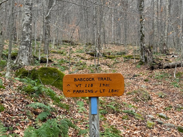 Turning onto the Babcock Trail, hikers heed the blue blazes up a gentle hill to return to their cars. The easy-to-follow trail rises slowly to a ridge. After reaching the heights, hikers encounter many signs of beaver activity at the swampy outlet of Big Muddy Lake. 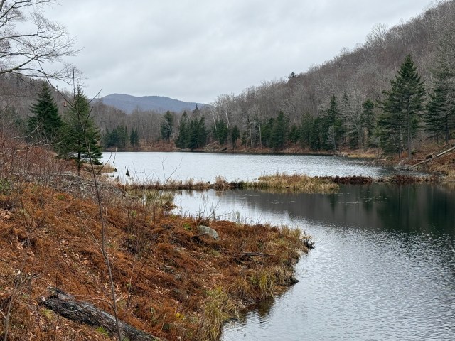 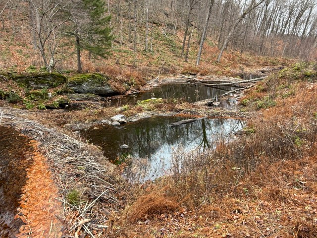 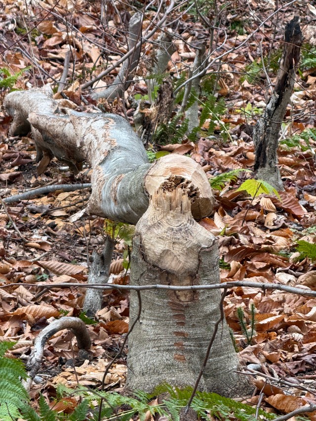 Beavers are very industrious. The size of the trees that they gnaw and fell is impressive. The “busy beaver” is an apt metaphor, as the second largest rodent builds strong dams for their homes, dramatically altering the landscape by creating a series of ponds at the outlet of Big Muddy Lake. It is an easy walk along the north side of the undeveloped lake, over a slight height of land, and down a moderate hill. 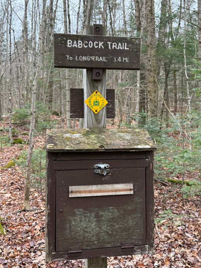 At the bottom of the valley, the trail meets Vermont Route 118, but not at the starting trailhead. Hikers cross the road to the trail’s end for the remaining 0.4 miles. The trail joins a dirt road for several hundred yards before veering into the woods. It is a short climb to the starting parking lot. 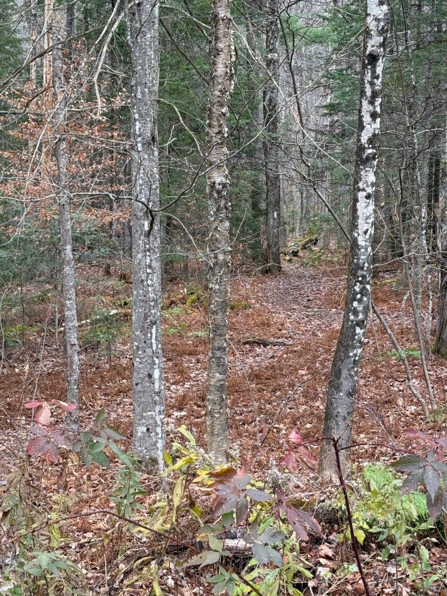 A view from the starting parking lot of the Long Trail starting north to Belvedere Mountain. That’s my next adventure! The Devil’s Gulch round trip takes two and a half hours to complete at a leisurely but steady pace. Exploration of the rocks in the defile and a lunch can extend the hike further. The elevation change is approximately five hundred feet, making the trail family-friendly. Trekkers can traverse the circuit in either direction. However, I recommend starting on the Long Trail and returning on the Babcock Trail as the latter avoids climbing the steep Long Trail rock steps around Ritterbush Lake. Winter travelers should use the Babcock Trail exclusively, as the hundred-plus rock steps would be dangerous.Those interested in a quintessential Vermont outdoor experience will enjoy Devil’s Gulch in any season. However, the stick season offers the unique advantages of solitude and vistas. |
Discover more from Researching the American Revolution
Subscribe to get the latest posts sent to your email.

Greetings, Gene. Enjoyed your account of exploring Devil’s Gulch. Went there many years ago. I do want to comment on the road Hazen’s men worked on. General Jacob Bayley had begun it in ’76 with plans to run from Newbury, VT, to St. John’s, Quebec. As you say, the idea of another incursion into Canada resurfaced following Burgoyne’s surrender but it never came to fruition. Preliminary implementation, however, began under Lafayette in late ’77 with the initial gathering of forces and continued work by Hazen on Bayley’s road. Some forces gathered in the upper Conn. River towns and they built forts and magazines. That plan fell apart by Feb., ’78, but the idea continued to be floated, albeit unsuccessfully, for the rest of the war. Work on the road continued off and on including building blockhouses along it. The Brits knew about the plans and sent parties out to find the road. After the war, the road served to channel settlers into that region of the Grants/VT. Portions of the road are still used today and other sections can be seen in the woods and fields.
LikeLike
Hi Mike. Thank you for your comment and for adding more information on the Hazen/Bayley road. Interest in the road is another demonstration that many Vermonters looked north for economic opportunities. Also, I have thought for a while that Jacob Bayley deserves a biography.
LikeLike
Vermonters spent a lot of time and made a lot of money trading with Quebec (and the British there). The B-H Road provided access in both directions. It’s only in the latter decades of the 20th century that border security became an issue limiting the trade.
You are right about Bayley–interesting character. There are a series of letters between him and Timothy Bedel that reference ponies in fields. I strongly suspect the two of them had some plan relating to land acquisition.
LikeLike